利尻礼文国定公園 1968 (昭和43) 5 月 10 日発行
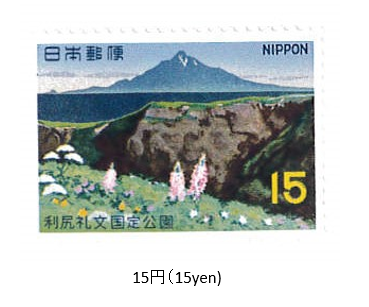
1968年 (昭和43) 5月、郵政省は利尻礼文国定公園切手1種を発行した。
利尻礼文国定公園は、日本海に位置する利尻島と礼文島と、北海道稚内市から豊富 (とよとみ) 町にかけての日本海沿いのサロベツ原野をエリアとする。公園面積241.66㎢。 1965年 (昭和40) 国定公園に指定された後、1974年にサロベツ原野を加えて国立公園に昇格した。利尻島は火山島で海上に浮かぶ。公園は山の中腹以上と沓形 (くつがた) 岬、天望台、御岬 (みさき) 、姫沼、オタドマリ沼の景勝地、チシマザクラ自生地などが含まれる。切手は、礼文島から利尻山を眺望する景色がデザインされている。
Risiri-Rebun Quasi-National Park Issued on 3 , 21 , 1968 (Showa 43)
In May 1968, the Ministry of Posts and Telecommunications issued a type of Rishiri Rebun Quasi-National Park Stamp.Rishiri Rebun Quasi-National Park covers Rishiri Island and Rebun Island, which are located in the Sea of Japan, and the Sarobetsu Wilderness along the Sea of Japan from Wakkanai City, Hokkaido to Toyotomi Town. Park area 241.66㎢.After being designated as a national park in 1965 (Showa 40), it was promoted to a national park in 1974 with the addition of the Sarobetsu wilderness.Rishiri Island is a volcanic island located at sea. The park includes more than the middle of the mountain, Kutsugata Cape, Misaki, Himenuma, scenic spots of Otadomari Swamp, and Chishimazakura's own habitat.
The stamp is designed with a view of Mt. Rishiri from Rebun Island.

